East Saline Creek to Little Mo./Athens-Big Fork Junction Trailhead
~7 miles
Saturday night was just beautiful. After we ate a few helpings of dinner, Kat went down to the stream to rinse out the pots. I piddled around camp some, gathering a few more sticks for the fire, going through my hammock-side nightly ritual.
Took out my contacts, found my glasses. Hung what was left of the food bag, covered and hung the pack up off the ground. Didn’t know if rain would come in overnight or not, but a few cold gusts of wind earlier in the day Saturday had us on alert.
Eventually, ended up sitting on the ground with my back against a log about a foot away from Kat relaxing in the same repose. Dusk turned to dark, all the quicker with our night vision ruined by the campfire.
Not sure we talked about anything at all for a while, but that’s usually a good sign. Rare to find a friend who knows what to do with a comfortable silence. I stood up to stretch my knees and the movement startled a pair of deer drinking just a few yards away at the creek. One doe jumped up the bank and stood on the trail staring at me, but I froze. Not sure if she could make me out on the edge of the fire or if she just figured me harmless. Watched her a little while until she walked back down to the water and then disappeared into the night.
It was the perfect night. I unzipped the outer shell of my hammock and let the cool air flow through the mosquito netting. I even kicked off my socks and slept barefoot – something I’ve never done in a hammock before. The only time I woke up was when the wind kicked up and slapped my rain fly against the hammock near my head.
We set the alarms for 5:00 a.m., still dark. Had just a hair over seven miles to go, but in those seven miles were five different peaks to cross. I breathed the fire back to life and began breaking down camp. Our last reliable weather report still had significant weather pulling into the area from the west around noon. Neither of us knew more than the elevation of each mountain we’d have to pass, and most of our experience has been hiking in the Ozarks.
All I knew was that bad weather was coming, my Yota was parked in a flash flood area, and there were several low-water bridges between the trailhead and home. Even after that, we’d be driving northeast through the storm if we didn’t get out in time.
We were on the trail by 6:30. I accidentally packed an extra raincoat, one of those bright red ponchos from the Walmart Duck Dynasty/Bear Grylls department. Because I hate hiking in a raincoat, I just used it as a pack cover – which provided me with the unintended but wholly awesome effect of having a Superman cape on my backpack.
Since we were heading northward, Brush Heap Mountain was just a 360’ climb about two miles out of camp. Just enough time to get the lungs working and warm up the legs. We both took our sweet time on the 709’ downhill into Blaylock Creek.

It started raining off and on, lightly, at 7:00. The views, even in an overcast and raincloudy day were just breathtaking. I can’t wait to see them on a clear day in late Fall or even again in early Spring.
The next few hours I spent climbing mountains mostly alone. I’d meet Kat at the summit where he’d been resting and, since I took my resting on the climb . . . we’d meet, make a comment about one down or about running out of mountain or something . . . and I’d head on down while he put his pack back on.

I won’t lie and say it was easy, but it certainly wasn’t as hard as either of us were expecting. I have to admire the marked reduction in switchbacks and the gradient was just perfect for a long, languid slog. Just my pace.

Saw these trees a few times, no idea what they are. This was in an almost tropical area on the north side of Brush Mountain.
We started coming across trashed campsites after Brier Creek Mountain, so Kat and I broke out the plastic bags and gathered up what we could. Amazes me, still, what some folks will leave behind. We humped out parts of a percolator, a folding shovel, various bits of plastic and foil packaging. In the last site, right before Hurricane Mountain, I found a trashed food bag all chewed up by animals. Had a few packets of tuna fish & drink mix in it along with a nice pair of Columbia shorts, a long-sleeved undershirt, and some long underwear. All looking in pretty new condition.

That led to some humorous verbal pondering about who may be running ahead of us pants-less and confused. I took the clothes home to clean ‘em so, well, if they’re yours and you end up realizing at the end of the hike that you don’t have any pants on . . . drop me a line and I’ll send them back. Your trash, though, we went ahead and left in a Mena trash can. Where, you know, it belongs.

Most of my pictures from that part of the hike are shots of the mountain ahead of me to climb, then a turn-around shot of the one behind me I just climbed. The air was misty-rainy so the pictures from that stretch aren’t great but a few turned out decently.


There were several clearings we came across while on the entire trail that looked like meadows cleared out by the Forest Service as feed areas for deer. This one in particular just sort of appeared on the trail ahead of us near the end.


Kat said this pic really didn’t capture the effect of that red poncho/superman cape flowing out behind me as I cut through that Elysium Field.

Made it off the trail at 11:30 on the nose, those last few steps of the trail blurring into a cheeseburger march. My Yota still sitting pretty where I left her. A fine light rain was coming down, but nothing like the toad-strangler we were expecting. We tossed the poles into the bed and crammed our packs into the back seat. I stopped long enough to get a picture of the Flash Flood sign and then tore out in a direction other than the one we came in from.

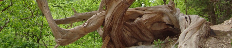
On the way out, I was tear-assing down a dirt road when Kat urgently commanded me to ‘Stop! Stop, you have to turn around!” He was wiggling around like a puppy on his first truck ride, which is not at all a usual affect for him. Grateful for my tailgate camera, I 3-pointed the Yota around and turned into a low, off-the road parking area/campsite that was positively trashed but behind it down a little skree embankment was this:

So we played a bit there, taking pictures, before heading all the way to Mena for gas and grub. Asked a couple of older locals where to get a great burger and they pointed us toward the Limetree Restaurant. Can’t say the buffet looked all that great, but the cheeseburgers went down just fine. For dessert we cut across to McDonald’s and were treated to this last and final waterfall. Not sure if it had a name, but we had a whole lot of fun imagining up one while we waited in the drive-through line.

Ty-D Falls? Porta Cascade?
Trip home was long but meteorologically uneventful. The storms did turn out pretty bad, but they slammed into the center of the state rather than the western edge where we were.
Next step is to contact the Ranger Station down there and see about getting an ERL patch.
{Kat & I got lucky with the weather that day, but other folks in the state were hit pretty hard. Read here for information on ways to help the tornado victims in Mayflower and Vilonia.}
